
The Tenney Lapham neighborhood is historic, urban, and changing.
In 1997, the Madison Landmarks Commission and the Tenney Lapham Neighborhood Association published a walking tour with great histories and old photos of twenty-six buildings. I snipped the map above from that publication.
In 2013, we need an interactive map. Not necessarily anything high-tech (the City has a google map of the "Capitol East District"), just interactive in the sense that it should result from neighborly interactions and it should create more neighborly interactions. The stories and histories embedded in such a map would add layers of meaning to the streets, buildings, and landmarks of our daily lives. I want to see people standing at a kiosk in Reynolds Park looking at it, talking, and telling more stories. And I want to watch the neighborhood continue to change beyond what we can capture on any map today.
A cultural map, ideally, is both geographically accurate and aesthetically interesting. Think of the map of the United States with an image of cows and cheese in Wisconsin and the Statue of Liberty in New York. Or the map at the zoo with pictures of animals where you can hope to find them. I want a map that graphically represents, to neighbors and visitors, what is there is to see and know about the area. What you can see now layered over a history lesson to inspire a sense of place.
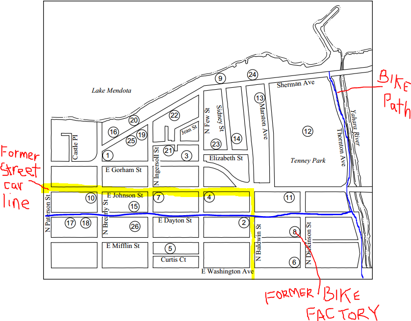
A neighbor of mine who lives in the house she grew up in, the same house she raised her kids in, first told me about the streetcar. She used to get on at Baldwin Street and take it downtown. If I ruled the 'hood, I'd paint white ghost lines on the blacktop where the tracks once ran.
Today there are white outlines of bicycles on East Mifflin Street. In 2012 the City added a "Bike Boulevard" through the heart of the neighborhood connecting downtown with the Yahara River path. It is defined by a confusing traffic signal and some street signs, but I'd like to note it also runs past the former Warner Bicycle Factory on North Dickenson Street.
One of a few existing historic markers is on East Dayton Street. Though they may not really remember what it says, I've noticed people bring it up in conversation and can describe the spot.
It is in front of the "Miller House," a plain-looking house with ghost-letters on the large glass windows from when it was a little grocery. The historic marker explains that the corner represents "the heart of a small historic Black neighborhood dating back to 1898."
Down the street is another sign noting the City Market building, originally constructed as a covered market for farmers to sell their produce in the city. It was briefly a dance hall but it's current iteration as an award-winning example of adaptive reuse neatly brings the neighborhood's history into modern times. Bike commuters roll past along the Bike Boulevard which is conveniently free of refrigerated trucks bringing milk to Madison Dairy every morning. I don't know the history of the Dairy, or even exactly when it closed (2009?), but I do remember those trucks.
I'd put all of this and more on a cultural map of my neighborhood.
No comments:
Post a Comment